Lefkada’s dramatic terrain — steep cliffs, high ridges, dry valleys, and sheer coastlines — reflects its complex geology. For hikers, understanding the island’s geology offers insight into how its landscapes were formed and why certain areas feel so distinctive underfoot. It explains the huge variety of scenery as you walk around the island.
Earthquakes and Fault Lines
Lefkada lies along the boundary of the >Eurasian and African tectonic plates, in one of the most seismically active zones in Europe. This plate interaction has caused uplift, folding, and faulting of ancient seabed materials, creating the island’s mountainous interior and steep western flanks. The “Cephalonia Transform Fault Zone” runs down the west coast – meaning a fault where the two sides slide against each other, associated primarily with frequent earthquakes. This lies in a deep trench off the west coast. Several thrust-faults or overthrust cross the island – where the two sides slide over or under each other, giving uplifted mountains and steep gorges. Stavrotas, at 1,158 metres, is the highest peak and part of a rugged range running down the island’s centre, caused by the uplift – with smaller examples across the island.

Although mountain building has been happening for millennia, it is very much still happening. Most recently, earthquakes in 1948, 2003, and 2015 reshaped parts of the island, especially in the southwest, where rockfalls and landslides are common. Each one of these earthquakes shifted Lefkada as much as 10cm upwards in the south and west, and a similar amount downwards in the north and east1. Repeated an average of every 23 years over millennia, this has shaped Lefkada – if constant, a metre uplift/sinking every 230 years. Incidentally, researchers can find no pattern in the delay between these bigger quakes – as far as they can tell it is random, from between 1 and 60 years, looking since 1577. Minor quakes are >every few weeks, although often unfelt.
Hikers may notice fresh cracks or rockfalls in these areas. Take care when near these cliffs or slopes as there are many loose rocks. Access is restricted to some beaches on the west coast because of the rockfalls – do not ignore closed off beaches or cliff areas. Even those minor quakes, or recent rain, brings down a rock or two.
Building regulations enforce strict codes and reinforced concrete beams, which greatly decrease the potential for damage. Traditional stone buildings, with a lattice of internal wood beams, have proved their strength through several earthquakes. The ones that weren’t built right aren’t here anymore.
There is also a unique design used, using wood framework upper-floors with a corrugated iron skin – used particularly in areas with soft ground, such as Lefkada Town. These were first built to replace earthquake damage, but have been retained as an effective design to mitigate future damage. They give a unique feel to the town as well as providing protection.
Tsunamis
As well as earthquakes, Lefkada has experienced tsunamis. There is a detailed study2 of the deposits that make up the Lefkada lagoon and areas around the canal. As this is protected from storms, it is a good place to study the tsunami record. The study finds that there are larger events every 500-1000 years with several smaller events between. Sea level changes through earthquake and tsunami sweeping through the Lefkada Sound, combined with silting from sea and rivers, have resulted in frequent changes to the lagoons and connections to the mainland.
In a further study3 examining and dating the sea bed in the Sound it is shown that there was an isthmus connecting Lefkada to the mainland when the ancient city was built in 700BC. It was then swept away by a tsunami about 300BC. This is exactly where the long bridge was built. So, presumably built after the isthmus was lost. This is in agreement with the historic sources and fills in or confirms some of the details.
Lefkada Town is now further north following the changed position of the mainland connection. The sea level is currently about 3m higher than it was when the ancient city was founded.
The studies also point out the unstable geography of the Lefkada Sound. There have been changes made by humans ever since the Corinthians first opened the canal. Nature too is a powerful force and the geological and other natural processes have not stopped.
Rocks and Formations

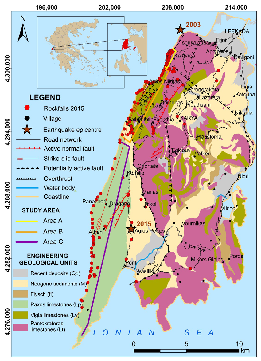
Lefkada’s striking scenery — from its towering cliffs to green inland valleys — is shaped by ancient rocks and active tectonic forces. Looking at the above map:
⛰️ Mountain Limestone (Pink and Khaki)
Much of Lefkada’s interior, especially around Karya, Eglouvi, and Vournikas, is formed from hard Jurassic limestone. The pink areas show massive Pantokratoras limestone, while the khaki indicates more thinly bedded Vigla limestone.
These rocks were once the floor of an ancient sea and are now pushed high by tectonic uplift. They form steep, rugged terrain with loose scree and dry streambeds. Landslides and rockfalls are common, especially along the west coast cliffs and fault zones — note the red dots showing 2015 rockfall sites near Exanthia, and Agios Nikitas.
Fossil hunters may spot bivalves and gastropods, although they are not abundant.
This limestone also has the potential for oil, and there are plans for drilling in the north-west Ionian Sea. It is a sea nature park leading to much controversy. There are also concerns about the potential for seismic oil surveys trigging earthquakes.
🌿 Younger Limestone and Rolling Hills (Green)
The green zones mark the Paxos limestone, a younger and more eroded rock. It creates smoother, lower hills in the southwest of the island, around Dragano, Komilio, and Panokhori. These areas are easier to walk but still rocky, often with olive groves and dry-stone terraces. Along the coast there are also steep cliffs – which had landslides and rockfalls during the 2015 earthquake – the red dots extend into this zone too.
🟫 Soft Sediments and Erosion Zones (Light-Brown and Yellow)
The light-brown areas show flysch — a soft mix of sandstone and shale. These are prone to erosion and landslips, especially after rain. Flysch is common around Poros, Nidri, Mikros Gialos, and in several inland valleys. Trails here can be muddy, unstable, or overgrown depending on the season.
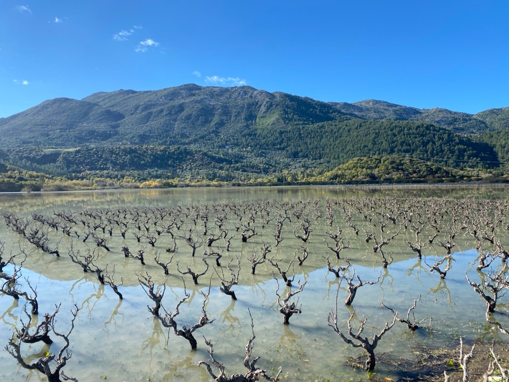
The light yellow areas represent Neogene sediments such as marl and siltstone. These softer materials weather into fertile soils, supporting vineyards and farmland near places like Agios Petros and Nikoli. But they’re also erosion-prone and can make footpaths slippery.
⚪ Coastal Plains and River Valleys (Grey)
The grey zones mark recent deposits — gravels, coastal sands, and marsh soils. These are flat and fertile areas around Lefkada Town, Nydri, and Vasiliki, where most settlements and lowland trails are found. Terrain here is gentle and accessible, suitable for easier walks and family outings.
Karst and Water Systems
Lefkada receives intense winter rainfall due to moist air from the Ionian Sea rising over its steep mountains, causing heavy orographic precipitation. Most rain falls between October and March, often exceeding 1,500 mm annually in central highland areas like Elati and Eglouvi. This seasonal pattern creates dry summers, flash floods in winter, and shapes the island’s erosion-prone trails and lush winter vegetation. Take extra care on roads and trails during and after heavy rain.
Limestone’s solubility in water leads to a karstic landscape: underground drainage, sinkholes, and intermittent surface streams. Permanent rivers are rare, and most streams run only during or shortly after winter rains. By summer, nearly all are dry. The exceptions are driven by springs, for example the Nidri waterfall and Syvros springs and waterfalls.
The Karya polje, a high plateau, shows classic karst behaviour: its flat, often flooded winter surface drains through underground channels, leaving it dry and cultivated by spring.

Mountainous Terrain
The most rugged terrain is found in the interior — around Karya, Skaros, and Eglouvi— where narrow ridges, rocky paths, and steep slopes dominate. These areas offer some of Lefkada’s most rewarding hikes, with panoramic views and a sense of isolation. Trails here often cross loose limestone scree, exposed faults, and ancient terraces clinging to steep slopes.

In contrast, the southern coastal zone is lower, greener, and more gently sloping — a reflection of its different rock types and erosion patterns.
A Dynamic Environment
In a geological timeframe, Lefkada’s landscape is still evolving. Its geological structure, tectonic activity, tsunamis, and erosional forces continue to shape the island’s form. Even in recorded history the changes have been significant. For hikers, every ridge, rockface, and valley is part of this ongoing natural history — visible and accessible through the island’s extensive trail network.
Understanding Lefkada’s geology not only enhances safety and appreciation during walks but also connects the hiker to the Lefkada geological clock, slow by human timespan, very fast as compared to the age of the earth. Humans observe this with their whole life akin to a smartphone photograph, with a brief section of motion, only a tiny part of the whole.
References
- Coastal deformation in Lefkada Island associated with strong earthquake occurrence – V. Karakostas, E. Papadimitriou, P. Patias and Ch. Georgiadis
. - Traces of Holocene tsunamis across the Sound of Lefkada –
A. Vött a, H. Brückner, S. Brockmüller, M. Handl, S.M. Maya, K. Gaki-Papanastassiou, R. Herd, F. Lang, H. Maroukian, O. Nelle, D. Papanastassiou.
. - Palaeoenvironmental changes of the Lefkada Sound (NW Greece) and their archaeological relevance – Svenja Brockmüller, Andreas Vött, Simon Matthias May and Helmut Brückner.
. - Rockfall Intensity under Seismic and Aseismic Conditions: The Case of Lefkada Island, Greece – Aikaterini Servou, Nikolaos Vagenas, Nikolaos Depountis, Zafeiria Roumelioti, Efthimios Sokos and Nikolaos Sabatakakis
.